Month: April 2013
FlightMap 1.6 Beta Released to Testers
I just released a new version of FlightMap to my beta testers. Hopefully all goes well and by this time next week this version will be out on the Play store for all to use. Here are the enhancements this BETA version includes:
- Updated graphics for the Airspeed and altitude Indicators.
- Modified the GA indicator to be in 20 knot increments
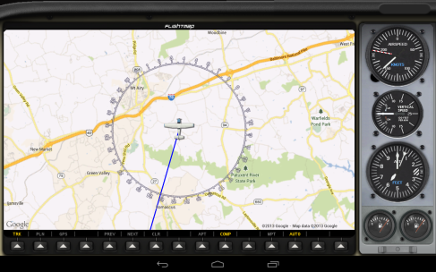
- Added a track option when in NAV or GPS mode. This allows you to toggle between the current heading up display and a north up display.
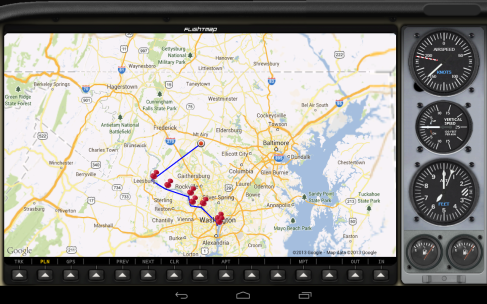
- Improvements to the adhoc waypoint system. Now when you get within 1 nautical mile of an adhoc waypoint flightmap will automatically advance to the next waypoint like the GPS mode does.
- non-active waypoints will have a gray line in adhoc mode and active waypoint will be blue as it is now.
- Added distance to waypoint in NAV mode
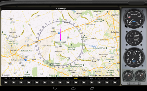
- Added distance to waypoint, ETE, CTS, DTK, and WP Altitude to GPS mode.
- Adjusted the compass rose in plane direction up mode. I was using a built in FSX magnetic direction variable but when I added track mode I noticed it was off a bit. I’ve now adjusted this so that it matches the north up mode. After some testing I believe it is far more accurate now than it was.
- some other minor graphic updates
Here are a few screen grabs of the latest version with the GPS enhancments.
FlightMap 1.6 Teaser Screens
Here are a couple of screenshots showing new features from the upcoming version 1.6.
I Just Love Udvar Hazy.
One of my favorite things to do is take my son over to Udvar Hazy. I always see new things and it’s such a joy to watch him run around the hanger. Right now he’s really into the Rockets and space shuttle which is always fun 🙂
Playing with a few panoramas 🙂
I love how they hang the planes. This is one of my favorite views
I just love the WW1 section. It’s so cool to see these old planes. It’s always shocking how small they are.
Preparing first update for Beta testers
I’m working really hard to get the first update out to my beta testers. Hopefully I’ll have that done Wed or Thurs this week. The first update includes the following changes:
- Updated graphics for the Airspeed Indicators. Also modified the GA indicator to be in 20 knot increments instead of 25 based off feedback from my testers.
- Added a track options when in NAV or GPS mode. This allows you to toggle between the current heading up display and a north up display.
- Improvements to the adhoc waypoint system. Now when you get within 1 nautical mile of an adhoc waypoint flightmap will automatically advance to the next waypoint like the GPS mode does.
- non-active waypoints will have a gray line in adhoc mode and active waypoint will be blue as it is now.
- Adding waypoint information for GPS and NAV display. The GPS mode will have more information than the NAV mode does. NAV will show distance to next waypoint. GPS mode will show magnetic bearing to waypoint, distance to waypoint, altitude of waypoint, and ETE for next waypoint.
This is a pretty significant update and I can’t wait to get it into my testers hands. If all goes well this update will be released next week for those that have purchased.
What’s next for FlightMap™?
Well, now that the hard part of actually releasing the software is out of the way I can start working on adding some new features to the app. I’ve had some requests for improvements to the Air Speed Indicator especially the GA indicator. Currently it’s in intervals of 25 and the request is for intervals of 20 so I’ll be updating that as well as improving the look of the gauge.
I’ll also be adding some improvements to the GPS mode. I have a bunch of data that I can overlay on the map about the next waypoint. Magnetic Bearing to Waypoint, ETE, Distance, Name, etc. I’ll be working on a way to make that information visible.
I’ve also had a bunch of other awesome requests. Some of them are:
- A night mode
- 7 inch tablet support
- Phone support
- Support for toggling plane tracking north along with the current tracking mode.
- Support for more map types like Sectionals and World Navigational maps
I also plan to do another app that I’m currently calling FlightGauges. I already have 4 of the 6 major gauges and I’ve had several requests for an app that just does that. This is on my radar to start work on after I’ve made some improvements to FlightMap.
As always keep feature requests coming. I’m monitoring the various forums and keeping track of all the awesome feedback. Thanks so much for the support
FlightMap™ Trial Released on the Play Store!
I just published the free 5 minute trial of FlightMap to the Play Store. It’s already showing up in the US store so it should be soon for other locations. The direct link to it is:
https://play.google.com/store/apps/details?id=com.vrs.flightmap.trial
The trial is fully functional and is tied to the server updates. Once everything is working it will get 5 minutes of server updates before the trial expires. You can re-open the trial as many times as you want.
FlightMap™ now Available on the Play Store!
Everything has aligned and we’re now starting to see the app in the various regions. It was available this morning on the US Play store when I woke up. Can’t wait to hear what people think once they get to using it.
I’ll be working to create a time limited free trial of the software tonight or tomorrow and hopefully have that up soon. It will give you 5 minutes of server updates before it stops updating the ui.
Check it out!!!
https://play.google.com/store/apps/details?id=com.vrs.flightmap
FlightMap™ launched on Google Play
Well, I think I’ve done everything I need to to launch the software. I’m just waiting for Google Play to show the app in the market. I’ll let everyone know once it’s showing up. I do not know how long that takes. FlightConnect has been released and it’s now available here:
https://vineripesoftware.wordpress.com/flightconnect/
Here’s some screenshots of the released version.
Release Very Soon!!!
I’ll be releasing the software this weekend. The Release Candidate testing has all gone well and I’m frantically trying to get the website and support materials completed. Life has gotten in the way of progress the last 2 days but I’ll be working on it tonight and hopefully have everything released soon. Here’s a few screen shots from one of the newer versions. The Release Candidate has a few updated graphics.
FlightMap Release Candidate Released to Testers
Tonight I’ve released the first non-beta build to testers. If all goes well over the next few days I hope to release the software to the play store on Wed. I’ve made a ton of performance improvements over the weekend as well as updated some graphics for the app. It’s really looking solid to me right now. I’m waiting to hear from my testers now. Exciting times 🙂
Copyright © All Rights Reserved.


